
We love the unique challenge that each client and project brings to us here at Hawkeye Access. As part of our services, we will discuss your needs thoroughly so that we understand what you need from us. We are happy to provide detailed quotes, and proposals if required, to ensure that we are fully transparent in what we can offer.
Below you will find information on what our standard services include however, we are able to think creatively and innovatively if you have a situation that might be just a little bit outside of the box - just get in touch.
-
3D Property Mapping
We build a 3D map and model of the property so we can understand the finer details, such as true size, contour level heights, and dam volumes.

-
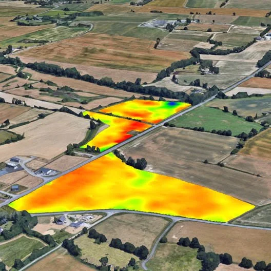
Plant Stress Mapping
Normalized Difference Vegetation Index (NDVI). Measuring Near-Infrared Light absorption to determine how much stress the plant is under. Enables forecasts of areas under stress 19-25 days before the plant shows visual signs.
-
Issue Identification and Mapping
Using machine learning (artificial intelligence) and the farmer to understand the issue and determine the size of that problem. Problems such as weeds and pest insects can be mapped and measured.

-
Point Clouds
Highly detailed point clouds can be used to create very accurate models of a building or work site. These models can be used to take measurements for redesign or future planning of a worksite.

-
3D Modelling
These models can be used to collect information on levels across the site for design and project management. Models can be produced into physical 3D models of a site for display and marketing programs.

-
Stockpile Calculations
For quarries and earthworks development this is a quick and accurate method of understanding how much stock is on-site or how much earth has been moved during the job.

-
Search and Rescue
Drone / UAV technology allows for large distances to be covered in a relatively short period of time to find missing pets, livestock or loved ones. The drone is not intrusive, meaning that disruption to the flora and fauna is minimised.

-
Videography
We are happy to work in with other providers to get you all the images you could imagine. We are also experienced in event videography for insurance purposes and can combine technologies to ensure all angles are covered.

-
Photography
Professional level equipment allows Hawkeye Access to capture beautiful, high-definition images of your topic of choice. This can be a stand-alone service or combined with aerial imagery to achieve your goals.
